
Asset Details


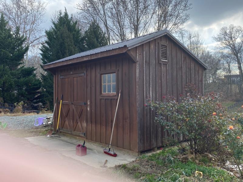


1,120 sq. ft. 3 bedrooms/1.5 bathrooms Single Family Residence built in 2001 situated on 2.4 acres more commonly known as 1166 Furniss Rd., Peach Bottom, PA 17563. Parcel No. 280-98247-0-0000.
Firearms Prohibited
Members of the public attending the auction are prohibited from carrying/possessing a firearm(s) at the auction, even if carrying/possessing a firearm(s) is otherwise permitted under state or local law. The term “firearm” means any weapon (including a starter gun) which will or is designed to or may readily be converted to expel a projectile by the action of an explosive.
Asset Info
Under the authority in Internal Revenue Code section 6331, the property described below has been seized for nonpayment of internal revenue taxes due from Jamie S. Waltman.
The property will be sold at public auction as provided by Internal Revenue Code section 6335 and related regulations.
ALL THAT CERTAIN lot or tract of land being situate on the south side of Furniss Road also known as Pennsylvania State Route SR 3004, in the Township of Fulton, County of Lancaster and Commonwealth of Pennsylvania, said lot being known as Lot No. 13, Block "A'' as shown on a Final Subdivision Plan prepared for Earl and Joanne Hershey & Clarence and Carol Wenger and known as "Furniss Hill Farms" by Strausser Surveying and Engineering, Inc., dated December 10, 1999 and last revised on June 26, 2000, said plan being known as Drawing No. 99207020, said plan being recorded in the Recorder of Deeds Office in Lancaster, Pennsylvania in Subdivision Plan Book No.- J-208 on Page No. 10 said lot being more fully bounded and described as follows-,
BEGINNING at a P.K. Nail set in the center of Furniss Road (SR 3004), a corner of lands of Jason D. And Helen W. Phillips and shown in Subdivision Plan Book J-203 on Page 73, said point being located 438 feet, more or less east of a point located in the intersection of Furniss Road (SR 3004) and Westbrook Road (Township Road T-462); thence in and along the centerline of Furniss Road (SR 3004) South 61 degrees, 59 minutes and 44 seconds East, a distance of 225.00 feet to a P. K. Nail set in Furniss Road (SR 3004) said point also being the comer of Lot No. 10 Block "A"; thence along Let No. 10, Block "A" the following three courses and distances; (1) South 27 degrees, 12 minutes and 34 seconds West, a distance of 43.96 feet to a Iron pin set, (2) South 57 degrees, 09 minutes and 38 seconds West, a distance of 36.04 feet to a Iron pin set and (3) South 23 degrees, 34 minutes and 0 1 seconds West, a distance of 372.38 feet to a iron pin set said point being in line of lands of Kevin H. & Cherry A. Heidenger; thence along lands of Kevin H. & Cherry A. Heidenger, lands of Vincent P. & Delores D. M. Deaugustine, and lands of Neal and Dawn D. Hough, respectively, North 84 degrees, 46 minutes and 21 seconds West; a distance of 243.53 feet to a iron pin set, said point being the corner of Lot No. 12, Block ''A"; thence along Lot No. 12, Block "A", North 26 degrees, 28 minutes and 58 seconds East, a distance of 334.26 feet to a iron pin set, said point being the corner of lands of Jason D. & Helen W. Phillips. thence along lands of Jason D. & Helen W. Phillips. as shown in Subdivision Plan Book J-203 on Page 73, North 27 degrees, 02 minutes and 58 seconds East, a distance of 206.86 feet to a P.K. Set, said point being the point of Beginning.
TOGETHER with and subject to an Access Easement over a portion of Lot No. 10, Block A, of the above--referenced plan, being more fully bounded and described as follows:
ALL THAT CERTAIN tract of land comprising an access easement adjacent to the northeastern side Lot No. 13 and the southern right of way line of Furniss Road, in the Township of Fulton. County of Lancaster and Commonwealth of Pennsylvania, said tract of land being shown on a sketch plan entitled Exhibit "A", dated November 20, 2000 and List revised February 14, 2001, prepared by Strausser Surveying and Engineering, Inc. and attached herein, said easement being more fully bounded and described as follows:
BEGINNING at a point an the property line dividing Lot No- 13 and Lot No. 10, said point being located South 27 degrees, 12 minutes and 34 seconds West, a distance of 17.33 feet from a rail road spike set, the most northeast comer of Lot No. 13; Thence commencing from the point of beginning along the south right of way line of Furniss Road, South 62 degrees, 24 minutes and 55 seconds East, a distance of 32.46 feet to a point; thence passing through Lot No. 10, the following two (2) courses and distances, (1), South 22 degrees, 49 minutes and 44 seconds West, a distance of 26.30 feet to a point, (2), North 63 degrees, 06 minutes and 15 seconds West, a distance of 34.47 feet to a rebar set at the comer of Lot No. 13; thence along Lot No. 13, North 27 degrees, 12 minutes and 34 seconds East, a distance of 26.63 feet to the Point and Place of Beginning.
BEING PART OF THE SAME PREMISES which Russell C. Greer and Hazel M. Greer, husband and wife by Deed Dated April 1, 1998 and Recorded April 3, 1998, in the Recorder's Office in and for Lancaster County, PA, in Record Book 5686, page 307 granted and conveyed unto Earle J. Hershey, Jr. and Joanne F. Hershey, Husband and Wife, as tenants by the entireties as to an undivided 50% interest, and Clarence R. Wenger and Carolyn M. Wenger, Husband and Wife, as tenants by the entireties as to an undivided 50% interest, and as to Hersheys and Wengers as tenants in common each with a 50% undivided interest.